
Shield volcanoes and stratovolcanoes are two major types of volcanoes. Other smaller-scale volcanic features also include cinder cones, volcanic domes, calderas etc. To put it simply, low-viscosity magma flows gently outward instead of erupts violently, resulting in shield volcanoes with gentle slopes. In contrast, stratovolcanoes form from viscous magma that often erupts violently and couldn’t flow far. The cooled lava layers near the volcano’s summit and creates steeper slopes.
This post summarizes nine shield volcanoes I have seen in the past. They are all in Oceania, with seven of them located in Hawaii, the ‘Mecca of Volcanology’… and yes, Hawaii is physiographically and ethnologically part of the Polynesian subregion of the continent of Oceania, not North America. :]
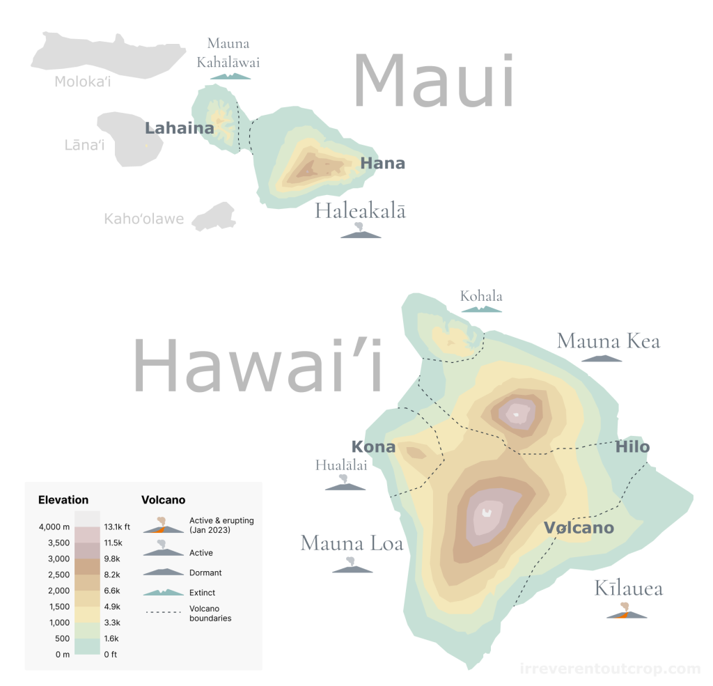
The island of Hawaiʻi (Hawaii’s Big Island)
The Big Island consists of five shield volcanoes with various levels of activity. Kilauea is actively erupting; Mauna Loa and Hualalai are active volcanoes but not erupting during our visit; Mauna Kea is dormant; Kohala is extinct. All volcano are named in Hawaiian language, which belongs to the Polynesian language group and has only five vowels (a, e, i, o, u) and eight consonants (h, k, l, m, n, p, w, ‘). Many place names seem quite long in Hawaii and can take visitors some time to get used to.

An interesting off-topic note: some opinions argue that the concept of ‘dormant volcano’ which is defined as ‘not currently erupting but has the potential to erupt again in the future‘ is too ambiguous. There were quite some examples of volcanoes defined as ‘dormant’ erupted recently that people need to be re-labeled as ‘active’. Therefore, there are calls to abolish the concept of ‘dormant volcano’.
The trigger to visit the Big Island was hearing the news of Kilauea’s eruption in early January last year (2023). Then we bought the flight tickets and visited during the MLK long weekend. For the outbound flight, I specifically picked a window seat and got to see the impressive view of Mauna Loa and Mauna Kea before landing. (Feel free to check out my other post about how to pick seats for your flight to enjoy scenic views without getting sunburned)

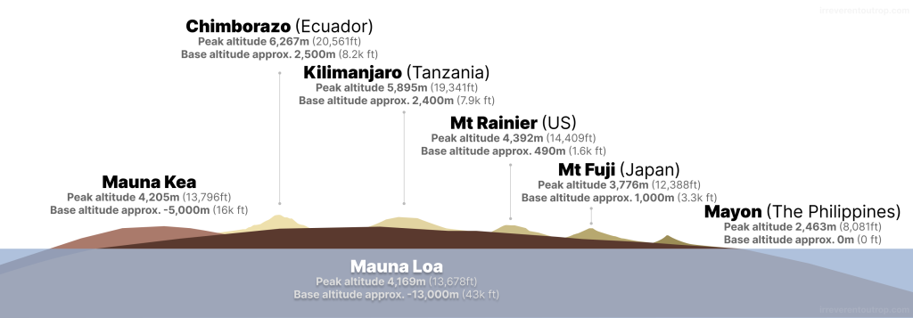
Mauna Kea stands at 4,207 meters (13,803 feet) above sea level. Mauna Loa, slightly shorter at 4,169 meters (13,679 feet), boasts a larger overall volume than Mauna Kea and is recognized as the world’s largest single mountain mass.
It is now widely accepted that the mantle plume hotspot responsible for the formation of the Hawaiian Islands is located in the southern part of the Big Island, near Mauna Loa and Kilauea volcanoes. The mechanism of mantle plume differs from the formation of volcanoes along mid-ocean ridges and subduction zones. Hawaiian Islands is the most typical example. Here, the mantle hotspot remains stationary while the Pacific tectonic plate moves linearly northwestwards, creating a chain of islands from Kauai through Oahu, Maui, and the Big Island. Other examples of hotspots around the world include the Galapagos Islands, Reunion Island, the Canary Islands, and so on.
Mauna Loa
The road from Kona Airport to Volcano Village goes through the southern part of the Big Island. Mauna Loa’s lava fields cover most of this region. The most recent eruption of Mauna Loa occurred in 2022.


From a parking lot near Kilauea, we could see the full expanse of Mauna Loa. What a flat shield!

Mauna Loa Road goes halfway up Mauna Loa on the southern slope. We could see the erupting Kilauea with smoke and the Pacific Ocean in the distance from up there. Elevational zonation is quite noticeable along the way: tall tropical trees dominate the foothills while shrubs prevail at mid-slope (as shown in the picture below). The road does not reach above the tree line so we couldn’t really see how the alpine zone is like near the summit of Mauna Loa.

On the windward eastern side of Mauna Loa lies the town of Hilo. Thanks to the northeasterly trade winds and the continuously riding elevation, this area receives abundant rainfall year-round, averaging 3,000 mm (120 inches) annually. Towering trees are everywhere and all the grass looks really green and dewy.


Mauna Loa’s northern slope abuts Mauna Kea’s southern slope. The only road that crosses the Big Island in the middle passes directly through the saddle section between these two volcanoes.
Mauna Kea
The last eruption of Mauna Kea occurred approximately 4,500 years ago. While its overall shape resembles Mauna Loa, the summit of Mauna Kea shows distinct jagged features caused by weathering and erosion. Because unlike Mauna Loa which is still an active volcano, Mauna Kea couldn’t replenish it’s mass with new lava anymore.

At the saddle where the two huge volcanoes meet, it may appear flat but it actually sits at an elevation of over 2,000m (6,500ft). The weather is constantly changing from cloudy to clear.


Mauna Kea hosts a vista point halfway up and an observatory at the summit. The vista point is accessible by all vehicles, but four-wheel drive is required to proceed further. We went during sunset with soft lighting casting a serene glow on the cinder cones dotting the slopes. As night fell, stargazing was exceptional. I bet the starry view at the summit must be even more spectacular.


On the windward eastern slope of Mauna Kea, there are dense tropical rainforests and waterfalls, similar to the vegetation near Hilo.


Kilauea
The trigger of this trip to the Big Island was Kilauea’s eruption, which started in early January. We visited in mid-January, and the eruption continued all the way until March. During our stay, we spent two nights at the village of Volcano. It was really conveniently located right next to the lava lake of Kilauea. We visited the overlook at the crater’s west rim on the first night, then the south rim on the second night.
The lava glowed red, churning within the lava lake, with cracks constantly changing on its surface. The fiery steam illuminated the night sky, creating a truly magnificent sight.


When we visited Kilauea’s lava lake during the daytime, we couldn’t see the lava glowing red, but interestingly we were able to notice gases emitting from the lava lake surface- sometimes blue sometimes yellow.

Kilauea’s north rim hosts a couple steam vents and sulfur banks. These geothermal features remind me of Yellowstone National Park and Rotorua of New Zealand.


www.irreverentoutcrop.com
As a distinguished Hawaiian Volcanoes National Park and UNESCO World Heritage site, Kilauea is not just about its crater. The entire southern slope stretching to the coast preserves extensive fields of a variety of solidified lava flows.
Lava flows fall into two morphological categories— the ones with smooth and ropy surface are called pahoehoe, while the brittle ones with brecciated surfaces are a’a (what a fun sounding name). Pahoehoe lava flows look more visually and gracefully contoured to me.


The lava near the coast appears to be darker in color.


A’a lava has a more rugged and harsh appearance. In theory, lava flows closer to the source are often pahoehoe which has higher temperatures. As they flow, they can transition into a’a, which is more viscous and brittle.

Ocean Island Basalts (OIB) like the ones here in Hawaii which is generated by mantle plume hotspots is chemically distinct compared to mid-ocean ridge basalts (MORB) and island arc basalts. OIB have lower SiO2 content and higher concentrations of heavy metals and other “incompatible elements”. We were able to find lava rocks revealing unique textures and sparkling crystalline structures, but I don’t think it’s easy to just identify those chemical characteristics with naked eyes.


Hualalai and Kohala
Hualalai is the westernmost volcano on the Big Island, located near the town of Kona. It’s not quite famous, but it’s actually an active volcano with the last eruption around 200 years ago. Kohala lying to the north is completely extinct though. There is few remnant of volcanic features of Kohala, but it has left behind spectacular coastal cliffs near Waipiʻo Valley.


That’s all about the five shield volcanoes of the Big Island of Hawaii, each with unique and fascinating forms. The Polynesian people naturally used local materials for their traditional architecture. Pu’uhonua O Honaunau Historical Park preserves some that we could visit nowadays. They were relatively newer and smaller comparing to the megalithic-style Nan Madol in Micronesia, which is constructed using basalt columns up to 40-50 tons (learn about my trip to Nan Madol).


Maui
Maui is to the northwest of the Big Island. It has two shield volcanoes: Haleakalā to the east, which is still considered active but not currently erupting, and Mauna Kahalawai to the west, which is extinct. The capital town of Lahaina, situated at the base of Mauna Kahalawai, was once an ancient capital of the Hawaiian kingdom but tragically turned to ashes in a catastrophic fire during the summer of 2023.


Haleakala
Haleakalā’s summit altitude is just over 3,000m / 10,000ft. It sits above the clouds. The volcano crater features several cinder cones with vibrant colors.

We could clearly see the lava-covered traces of past eruptions from the side.

There’s an observatory at the summit. It almost looks like a Mars base station with it surrounding barren rocks. We also spotted a chukar bird and a kind of plant called ‘silversword’. Chukar is not native to Hawaii, but silversword is, and it’s exclusively found on Haleakalā’s summit. Silversword is critically endangered that there were only 41 naturally occurring ones in 2003. Conservation efforts have since helped their numbers slowly recover.


The coastline at the foot of Haleakalā has numerous lava remnants, showing extensive signs of erosion due to its long dormancy without eruptions.


Mauna Kahalawai
Mauna Kahalawai on the west side of Maui is an ancient extinct volcano. Without recent volcanic activity or tectonic uplift, erosion dominates the landscape, resulting in numerous steep valleys. Nutritious volcanic soil, year-round tropical climate and abundant rainfall support dense vegetation and excellent ecological conditions. ʻĪao Valley on the volcano’s east slope is a great example.


Makaluapuna Point on the western slope of Mauna Kahalawai features a unique “Dragon’s Teeth” landscape. After lava flowed into the sea and cooled rapidly, it then underwent continuous erosion by waves and eventually formed extensive basaltic coastal cliffs with jagged edges.

www.irreverentoutcrop.com
Just to the north of Makaluapuna Point, Honolua Bay offers a great spot for snorkeling. But the Magical Enchanted Forest along the Honolua Bay’s trail before we got to the coast actually impressed me more. It’s an area of protected forest as well as an ancient Polynesian burial site. The tropical rainforest landscape here is extremely lush, with gigantic trees and robust vines intertwining everywhere.


There is a clearing surrounded by dozens of massive banyan trees, along with hanging vines and moss. Despite the bright sunshine outside, hardly any light penetrates here. Cool breezes blow through occasionally. The whole atmosphere felt like a magical place where fairies might appear. We didn’t see many other people when we visited.

We went to the Sun Yat-sen Memorial Park for the last sunset before leaving Maui. Maui is where Sun Yat-sen (a.k.a. the “Father of Modern China”) first came to Hawaii to seek refuge with his brother Sun Mei. Now there is a memorial park on the west slope of Haleakala, which is a good place to watch the sunset.


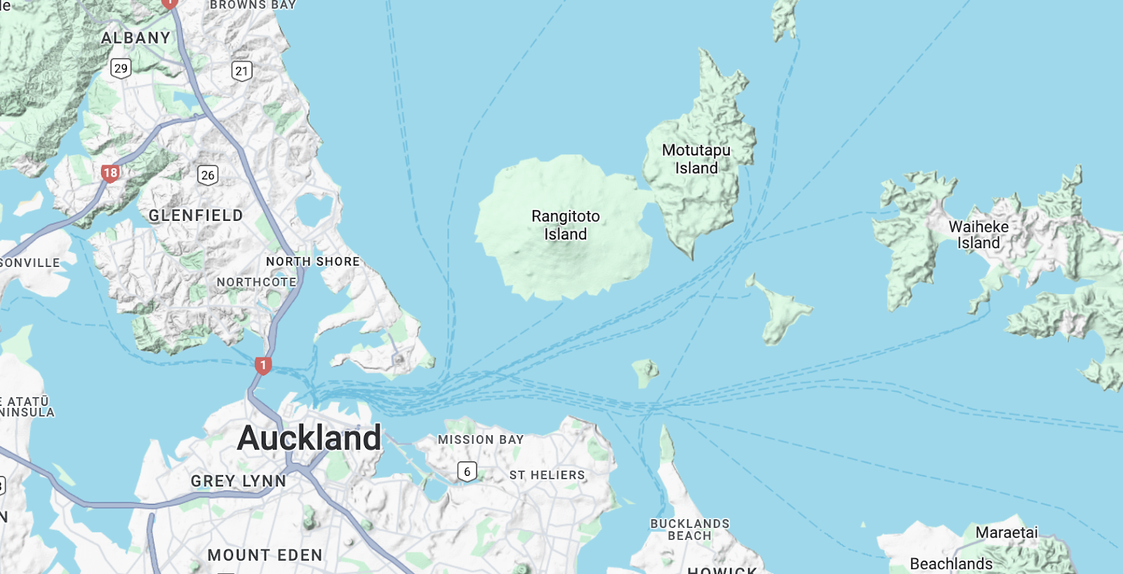
Rangitoto, New Zealand
Rangitoto is a dormant shield volcano off the coast of Auckland, North Island, New Zealand. It looks particularly round as a stand-alone island on the map.
New Zealand’s North Island is full of volcanoes, but Rangitoto is the only shield volcano. The country’s other two shield volcanoes are both on the South Island- both extinct, and heavily eroded.
The city of Auckland offers a side view of Rangitoto. Compared with those world-class giant shield volcanoes in Hawaii, Rangitoto is much smaller in size. But it’s easy for people to see the overall shape of the ‘shield’. There is a ferry at the central pier that connects to the island. The summit of Rangitoto is 259m (850ft) above sea level. It’s not a difficult hike.

There is a small extinct cinder cone in the city of Auckland called Mt Eden. I could capture a view of Rangitoto in the same frame with the skyline of downtown Auckland. It is pretty nice.

Lord Howe Island, Australia
A 6.9 million-year-old shield volcano sits right in the middle of the Tasman Sea between Australia and New Zealand. Most of the volcano has been eroded below the sea level, leaving only a narrow arc-shaped island exposed above the sea. This is Lord Howe Island. This little paradise is 11km/ 7mi long from north to south, 2km wide at its widest point from east to west, and has a maximum altitude of 875m/ 2,870ft. It has more than 300 permanent residents and a maximum tourist capacity of 400 people.


As part of an oceanic volcano, the entire island is made of basalt. Most mountains are heavily eroded. After getting off the plane, I noticed the twin peaks of Mt. Lidgbird and Mt. Gower right away.

The next day I climbed halfway up Mt. Lidgbird and looked back north. I could see the “Ↄ”-shaped arc of the entire island just like how it appears on the map.

Sheer cliffs at the bottom of Mt Lidgbird drops right into the sea and offers a majestic view from the rocky beach.

On a sunny morning during my stay, I climbed up the northern hill and looked towards the south. The “Ↄ” shape turned into a “C”. I could also easily identify the boundary of the lagoon.


The volcano’s underwater terrain provides a good seabed for coral reefs. Coral reefs still thrive here even though it is far away from the tropics. They are cold-water corals. Lord Howe Island is at 31.5° S latitude, which also marks the southern boundary of the distribution of the world’s coral reefs. FYI- the northern boundary is at Tsushima Island, Japan, at 34° N latitude.


Neds Beach on the north side of the island is not big, but groups of big fish wold just swim right at my feet and they are not afraid of people at all.


By the way, Lord Howe Island Airport (IATA: LDH) is the smallest airport I have ever been to. People would set up a small tent for check-in when the plane arrives, then they’d remove it after the plane departs.

In addition, due to the unstable weather and the fact that the plane is a small propeller plane, this once-a-day flight route between Sydney and LHD is greatly affected by the weather. When I first time went checkin at Sydney airport, it was windy at LHD so I had to go back and wait for a whole night and come back the next day.
As for plane tickets, the cash price is always crazily expensive but it is quite cost-effective to redeem it with Qantas miles, because the flight distance from Sydney is not far at all. The logic is similar to that the highest ‘value’ of Alaska Airlines miles redemption is for flights between remote villages within Alaska, while the highest ‘value’ of United Airlines miles redemption is for flights to remote islands in Micronesia.
The end
That’s the end of this post about shield volcanoes! There are many other cool shield volcanoes in the world, such as Piton de la Fournaise of Reunion, Erta Ale of Ethiopia (the lowest volcano in the world), Masaya Volcano of Nicaragua, Mount Wrangell of Alaska, Santorini of Greece, and that big group in Galapagos. Hope I can visit them some time in the future!
www.irreverentoutcrop.com