
In the afternoon of our third day in Greenland, we departed Nuuk aboard a small Air Greenland plane heading for the tiny settlement of Kangerlussuaq. This village sits quietly just inside the Arctic Circle, right next to the massive Greenland Ice Sheet.

A bird’s-eye view of the ice sheet and glaciers
Nuuk was overcast, but once the plane climbed above the clouds, we were able to see numerous horns poking through the cloud cover.

Approximately 40% of the way through the flight, we reached latitude 65.3°N (65°17′ N), where we could see the endless Greenland Ice Sheet stretching out from the east-side window, with a massive glacier extending from it. This is the Saqqap Glacier, known in Greenlandic as Saqqap Sermia: saqqa means “in front of,” -p is the possessive case ending, and sermia means “glacier.” So it roughly translates to “the glacier at the front”. It’s quite a down-to-earth name.

Shortly after flying past the Saqqap Glacier, we found ourselves directly above the Marjorqaq Glacier.

Immediately north of the Marjorqaq Glacier lies the western extension of the main Greenland Ice Sheet, known as the Tasersiaq Ice Cap. Several of the glaciers in this area originate from this ice cap and another one called the Kangaamiut Ice Cap, which is further west and not visible from my side of the plane.
An ice cap is essentially a smaller, typically dome-shaped version of an ice sheet.

The northern edge of the Tasersiaq Ice Cap borders the lake of the same name, Lake Tasersiaq. Several valley glaciers on the north side of the ice cap flow into this lake.

Wedged between the main Greenland Ice Sheet and the Tasersiaq Ice Cap is a smaller ice cap called the Amitsulôq Ice Cap. We could see that it forms a lovely circle from the air, with a noticeable elevation rise at its center.

If we were to map all the locations mentioned above, the route would look approximately like the map below. Since I was seated on the east side window, I have spinned this route map to represent a view looking from west to east.
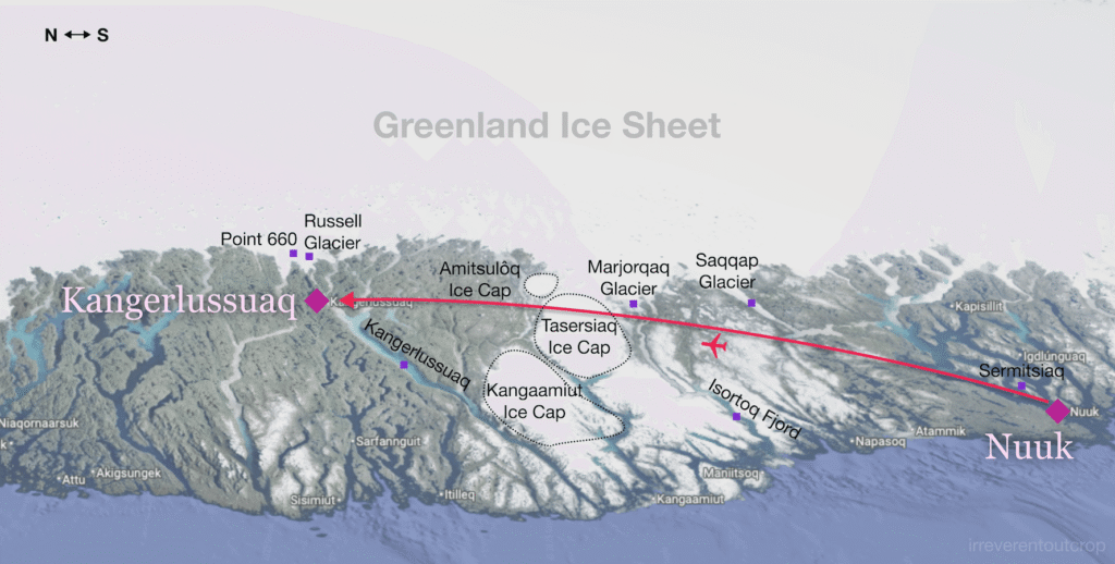
This entire area we flew over was incredibly spectacular, featuring magnificent mountains, lakes, glaciers, and fjords. However, finding the place names was quite a challenge because it is largely uninhabited; most are only mentioned in scientific papers dedicated to glacier research. Since I managed to track some down, I went ahead and added a few of them to Google Maps. For some additional thoughts on the “confusing” nature of Greenlandic place names – a truly interesting topic involving history, decolonization, and linguistics – feel free to refer to the end of my previous post about Nuuk.
Shortly after entering the Arctic Circle, we began preparing for landing. The small town of Kangerlussuaq is located at the head of the fjord that shares the same name.


Kangerlussuaq: “the big fjord”
The flight from Nuuk took only about 50 minutes, and our plane landed smoothly at Kangerlussuaq Airport.
Kangerlussuaq means “big fjord” in Greenlandic: Kangerluk is fjord, and ssuaq is big. Despite the name being long and complex to spell, the lack of a shortage of fjords in Greenland means there are many fjords called “Kangerlussuaq” or similar derivatives. However, this is the only settlement that goes by this name.
With a permanent population of only 400, Kangerlussuaq is quite unique in Greenland, both geographically and historically: it is the only town directly next to the ice sheet, the only inland town, and historically, it did not develop as a natural Inuit village but evolved from a US Air Force base established during WWII. Before 2024, it served as Greenland’s largest international aviation hub. Even after the passenger hub moved to the capital Nuuk in late 2024, the airport retains significant cargo and military transport services.
Since the village is not coastal and the inner harbor has limited capacity, the local economy is entirely dependent on the airport, tourism, and military investment. This is clearly evident to visitors: the airport terminal is the heart of the village, housing the hotel, gift shops, restaurants, tour operators, and administrative offices. The prices at the supermarket across from the terminal are surprisingly fair, even cheaper than in Nuuk or mainland US. The fruits and vegetables are also notably fresh. It seems logistics are well-assured wherever the military is involved. The cellular service and the guesthouse WiFi were also the fastest and most stable we encountered on the entire Greenland trip.
Accommodation and dining options are scarce, but the quality is dependable. We found the hotel in the terminal is too expensive so we ended up staying in a small guesthouse nearby, which required sharing a bathroom. As for restaurants, there are only three in the village: the best one is located near Lake Ferguson and offers a complimentary shuttle, while the other two are on the second floor of the airport terminal.

The small restaurant by Lake Ferguson looked quite low-key from the outside, but the interior was sophisticated and tidy, suggesting a rather high-end establishment.


The food was high-quality and made excellent use of unique Greenlandic Arctic ingredients. During our three days in Kangerlussuaq, we had two dinners here. On Monday we tried the ptarmigan; the meat was quite chewy and had a slightly strong flavor. Wednesday night featured the weekly buffet, which highlighted traditional Inuit specialties: whale skin (maktaaq), halibut, lumpfish roe, reindeer, musk ox, and more. It was a great opportunity to sample authentic local cuisine, and the unlimited portions made it an excellent value.


Behind the restaurant counter was a row of schnapps brewed using local berries or wild flowers. The bottle on the far left was the emptiest, clearly the most popular. The small print on its label read “Ptarmigan” so we asked the staff what that meant. Then she told us that the schnapps was made from semi-digested blueberries found in the crop (gizzard) of the ptarmigan bird!
The price was a bit steep, but we tried a small glass anyway. It had a very high alcohol content, yet the texture was smooth, the fruit aroma was striking, and the complex flavor profile was quite layered.

The Greenland Ice Sheet and the Russell Glacier
The highlight for any visit to Kangerlussuaq is definitely seeing the ice sheet, along with the adjacent Russell Glacier. We booked a truck day tour. The itinerary was straightforward: Greenland Ice Sheet in the morning, packed lunch of sandwiches, then the Russell Glacier in the afternoon.


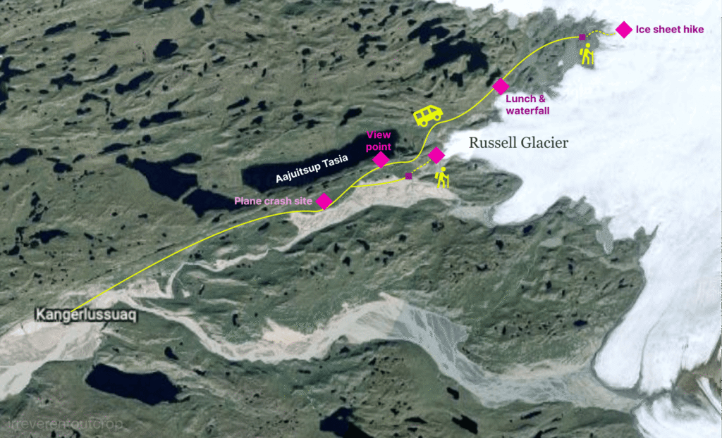
After setting off in the morning, we first passed a site of a US military plane crash, followed by a lake called Aajuitsup Tasia.


Greenland Ice Sheet
The dirt road ended after more than an hour of driving. Our truck stopped next to a moraine at the edge of the ice sheet. Then our guide led us hiking over the moraine and walking towards the ice cap. The fog had completely cleared by then, leaving excellent light under a blue sky with white clouds.


The ice sheet appears to be quite flat and smooth from afar, but once we were on it, we found that the ice surface actually has all sorts of uneven, textured formations.


Ice beneath the surface has less bubbles and the color would looks darker. It’s called “black ice”.


The Greenland Ice Sheet covers 80% of Greenland’s territory with an average thickness of 2km/6500ft. If the entire ice sheet were to melt, global sea levels would rise by 7m/24ft. Although we were only at the very edge of the ice sheet, the sheer grandeur of the place was already palpable.


Upon reaching the site known as “Point 660,” we saw a small scientific device. There are several more research stations deeper within the Greenland Ice Sheet, but those are only accessible to researchers and are off-limits to regular tourists.


A brief interlude
While walking back from the ice sheet, we noticed a military helicopter circling overhead. Initially we wondered why a military helicopter would be operating in such a remote location…

After crossing the moraine, we realized there were hundreds of soldiers dressed in green or white camouflage, carrying live weapons, with black or green paint smeared on their faces, heading toward the Ice Sheet. We looked at their shoulder patches and saw that the vast majority were active-duty Danish military personnel, but we also spotted the German flag among them.


This was the first time in my life seeing military activity at such close range. Once I had mobile reception back in town, I quickly looked it up and found out it was the “Arctic Light 2025” military exercise, one of the largest held in Greenland in recent years. In addition to Denmark, participating countries included Germany, France, Sweden, and Norway. We did see many more German, Swedish, and Norwegian military personnel over the next few days in Kangerlussuaq, though we didn’t spot any French – they were reportedly involved via warships, which might have been the ones we saw earlier in Nuuk.
Later while watching TV in our guesthouse in Ilulissat, the local news covered the military personnel on the ice sheet. Looking at the background of their interview, it was clearly near the Point 660 location we had just visited!
Lunch
Leaving the area where the military exercise personnel had disembarked, our vehicle drove for about 15 minutes before our tour guide stopped near a waterfall on the north side of the Russell Glacier and let us out for lunch. Everyone was given a sandwich, which tasted quite good.

The surface of the Russell Glacier is covered with numerous crevasses, and a large expanse of moraine is visible in front of it. Upon a closer look, we could also see a large snout collapse. The surrounding ring-like tension cracks are the result of this collapse. This feature is distinct from a moulin: a moulin is typically found away from the glacier’s edge and is a circular, vertical shaft formed by meltwater spiraling downwards, using carried debris to drill, abrade, and erode the ice wall.


In addition to the distant glaciers, the textures on the gneiss outcrops beneath our feet were also spectacular. The gneiss here is a few hundred million years younger than the 3.6 billion-year-old rock found in Nuuk, dating to approximately 2.8 billion years ago, but it still belongs to the Archaean Eon.


To get closer to the Russell Glacier’s ice tongue, we needed to backtrack to that large lake and then take a detour down a side road. This path was a bumpy ride leading all the way to a riverbed, where we then got out and began hiking upriver from west to east toward the glacier.
When we returned to Lake Aajuitsup Tasia by the afternoon, the clouds and fog had completely lifted, allowing for a clear view of the pristine lake waters and the ice sheet in the distance.

The walk along the riverbed to the ice tongue of the Russell Glacier was actually quite a long distance, and we frequently encountered muddy sections. Fortunately the terrain was mostly flat, so the trek was not exhausting.


After a long but fun walk, we arrived right in front of the Russell Glacier! The ice tongue of the Russell Glacier extends into the lake formed by its meltwater, and its terminus is constantly calving. This is a valley glacier, and its morphology is quite distinct from the “piedmont” or “elephant’s foot” shape of a glacier terminus where the ice thins out and spreads.

By circling around to the north side of the ice tongue, we were able to see the Russell Glacier from a different perspective.

Similar to lunchtime, while looking up at the glacier, do not forget to look down at your feet! The bedrock here is largely exposed gneiss, where alternating dark and light mineral bands twist into various folds, demonstrating the intense metamorphism that once occurred in this area. The surface of all the rocks is exceptionally smooth, clearly a result of glacial abrasion.


With the glacier towering above and the Archaean gneiss underfoot, and the weather being perfectly sunny and mild, I truly felt I could stay here all day.


Moving further ahead, the jointing in the bedrock became much more fractured.

Here we could also spot several examples of boudinage! When brittle rock layers are sandwiched between relatively ductile layers and the entire mass undergoes strong extensional deformation, the brittle layers are stretched and necked down, eventually breaking apart to form sausage-shaped structures. The ductile layers, however, do not break and can instead flow to fill the voids created by the necking of the hard rock layers.

If we had more time, we probably could have walked right up to the proglacial lake to see the calved ice blocks up close. Unfortunately, time was limited, so we could only admire them from a distance.

As I started walking back, I kept feeling like I hadn’t spent enough time there, constantly wanting to turn around and steal a few more glances.


Military exercise was still underway after we returned to the village, with helicopters constantly taking off and landing.


Before the sun fully set and it got dark, we took the opportunity to explore more of the village. The airport runway divides the village into northern and southern parts. The main tourist areas are concentrated in the north, while the south primarily consists of local houses and industrial facilities. I was quite surprised to find that a village of just 400 people inside the Arctic Circle still has a bus system!


Black Ridge, fjord, and fossil plain
We visited a few more interesting sights near the village on our final day in Kangerlussuaq.
Black Ridge
Early in the morning, we took the “easy route” and called a taxi to take us to the top of the hill opposite the village, known as “Black Ridge.” As the car was leaving the village, we encountered a checkpoint set up by the military exercise personnel. After asking where we were going, they allowed us to pass. It was the first time I had ever been questioned by armed soldiers carrying live ammunition.
Black Ridge is not particularly high when it comes to elevation, but it offers excellent visibility and is a 360° panoramic viewing spot.
Looking first toward the northwest, we could see a sweeping view of the entire village and the airport runway. The gneissic bands on the cliffs behind the village were beautifully highlighted by the morning sun.

Then when we looked west along the river, we saw the braided riverbed of the Qinnguata Kuussua River extending into the distance, where the river meets the beginning of the fjord.

Lake Ferguson is to the south of Black Ridge and the ice sheet we had visited is just upstream along the river towards the east.


Turning to the northeast, we looked over the river flats and meadows of the upper Qinnguata Kuussua River.


The path down from the top of the ridge was easy to navigate, and we reached the foot of the hill shortly.


Looking up close at the cliff face of Black Ridge from the foot of the hill was quite spectacular. The entire mountain had been polished smooth by the glacier, and the thin layer of soil at the base was covered with crowberries. Several local kids, led by what appeared to be a teacher or parent, were boldly climbing up the slope using a single piece of rope.

The village entrance has an iron bridge crossing the Qinnguata Kuussua river. Since September is likely the low-water season, we could see the large, uneven riverbed from the bridge. The riverbed’s bedrock was heavily eroded and cut into grooves and hollows by the glacial meltwater carrying vast amounts of abrasive material.


The main stream of the river did not look voluminous, but the water flow was still rapid. The milky-white, slightly grayish-green glacial meltwater offered a completely different texture.


The dense grooves on the white bedrock, the braided patterns formed by the deposited dark sediment, and the ripples of the flowing water combine to create a maximalist beauty unique to the Arctic wilderness.

Fossil Plain
After returning to the village from Black Ridge, we took a brief rest after lunch, and decided to take a walk to Fossil Plain later in the afternoon.
Fossil Beach is about 5 km away from the village center, which takes about an hour to walk each way. The walk is very easy and entirely flat – just keep heading west, and you won’t get lost. The continuous and intact expanse of gneiss cliffs on the north side accompanies the entire journey. The top of the cliff is about 300m / 1,000ft above sea level, and because the entire face is uncovered by vegetation, the textures resulting from metamorphism are exceptionally clear. We even spotted quite a few massive boudinage structures.

This so-called Fossil Plain is actually a dry riverbed on the north bank of the Qinnguata Kuussua River, located at a higher elevation than the current riverbed.


The riverbed is mostly made of cracked mud flats, with occasional patches of yellow grass growing on them.

It’s probably because this Fossil Plain is right at the mouth of the fjord and there isn’t any big physical barriers, the wind is strong and constant. The wind, the dry riverbed, and the scattered pebbles really reminded us of the Racetrack Playa in California’s Death Valley.


We didn’t see any fossils though.
Bye for now, Kangerlussuaq!
Our time in this small ice sheet village quickly came to an end. On our final night before leaving, we saw a spectacular display of the aurora borealis, which served as a perfect finale. Kangerlussuaq’s weather is generally much drier and clearer than other Greenlandic settlements as an inland village. It’s an ideal observation spot when the aurora bursts forth.


Our next stop will be the Ilulissat Icefjord!