
We took a trip to Baffin Island (i.e. “Qikiqtaaluk” in Inuktitut, meaning “very big island“) in August 2025, exploring lively permafrost, ancient rock formations, and spectacular Arctic fjords, while also getting a glimpse of the unique lifestyle of Inuit people today. This trip was overflowing with fascinating and thrilling experiences, far too many to capture in a single post. I’ll tell the story in three parts:
- Iqaluit, the capital of Nunavut;
- Pond Inlet, an Inuit village in northern Baffin Island; and
- Pangnirtung, an Inuit village at the entrance to a magnificent fjord.
This first post below will be about Iqaluit and the journey getting to Iqaluit.
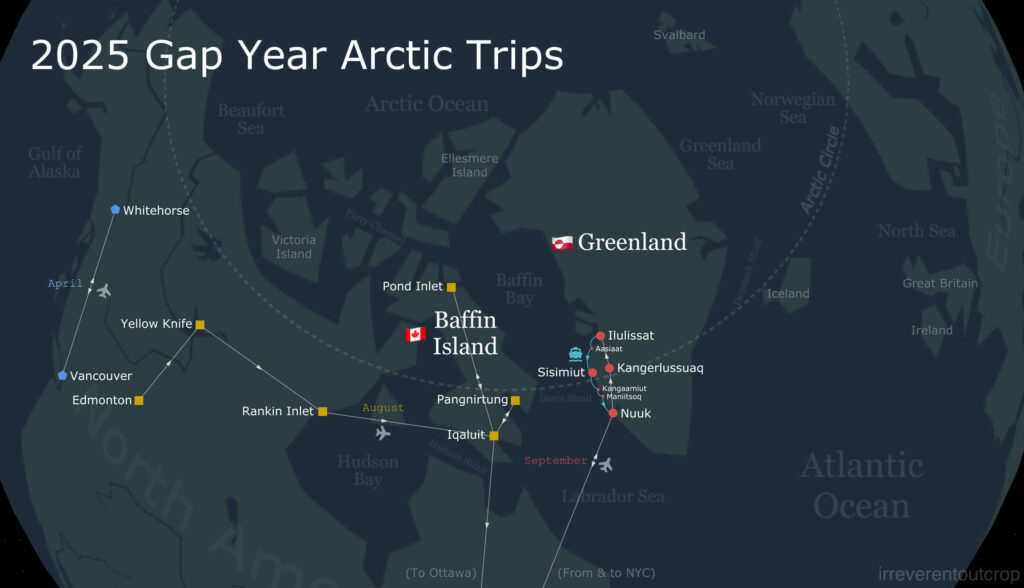
For those interested in what I did in the Yukon back in April, feel free to check out my last post.
About Nunavut
Nunavut is a territory of Canada, established in 1999 after being separated from the Northwest Territories. It is also an Inuit self-governed territory. “Nunavut” is written as ᓄᓇᕗᑦ in Inuktitut, which means “our land”. The territory only has a population of about 40,000, spread across 1 town and 24 villages (i.e. hamlets) that are completely disconnected by road. Five out of every six residents are Inuit.
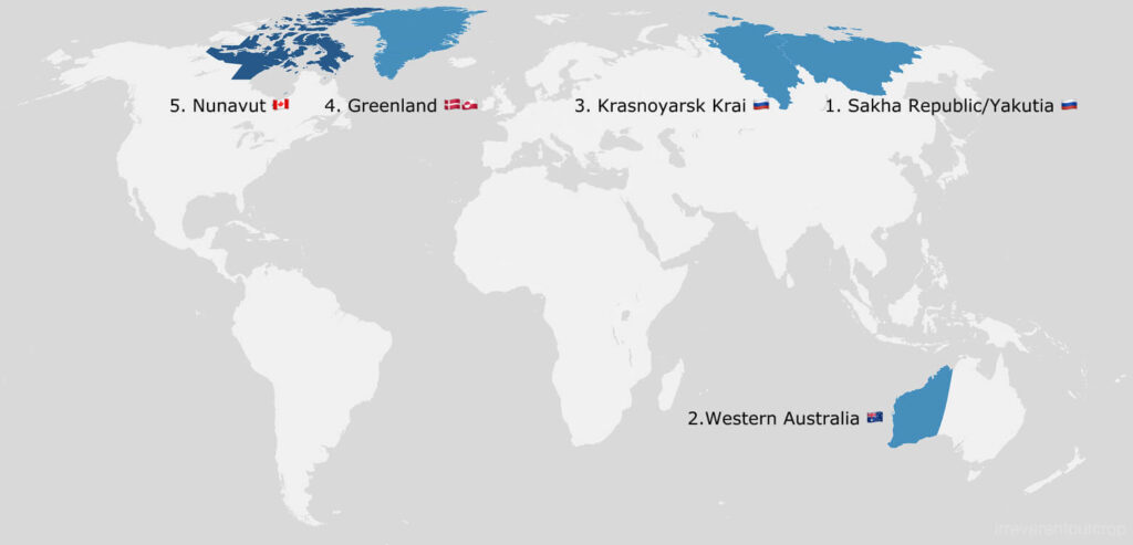
Nunavut covers a huge area of about 2 million km², roughly the size of Mexico, about 20% larger than Alaska, or 3x the size of Texas. It’s the world’s 5th largest first-level administrative division by land area. The top four are Sakha Republic/Yakutia (Russia), Western Australia, Krasnoyarsk Krai (Russia), and Greenland.
That’s why when it comes to population density, Nunavut has only about 0.02 people/km² – that’s roughly one person for every 50 km². Even Greenland’s population density is 30% higher than that, which shows just how sparsely populated Nunavut is! By contrast, Macau has about 20,000 people/km², meaning its density is literally one million times that of Nunavut.
What made me want to visit Baffin Island? Well, there were three main reasons:
- First, the book Atlas Obscura has a section about “Spaceship Architecture of the Arctic“, and I noticed that many of the featured buildings are in the capital, Iqaluit.
- Second, I learned that Canada has several national parks in the Arctic, but only Sirmilik and Auyuittuq can be reached by regular commercial flights and both of them are on Baffin Island.
- Third, I’ve often believed that places with greater elevation differences tend to have more dramatic scenery. While most of Canada’s Arctic regions are quite flat, Baffin Island is a rugged exception. On our flight from Iqaluit to Ottawa, the elderly gentleman sitting next to us completely agreed. He had spent his entire career as an engineer with Canadian North Airlines and had been to every Inuit village in the Canadian Arctic, so I’d say his opinion would be quite convincing!
Logistics
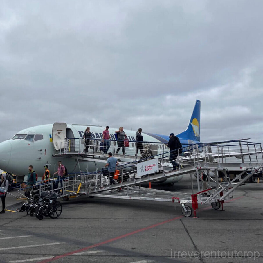
✈️Flights: Canadian North Airlines has a monopoly to most of the Inuit villages, so their flights’ cash fares are terrifyingly expensive. I strongly recommend taking advantage of their partnership with Air Canada and redeem Aeroplan miles for Canadian North flights. It can yield quite some excellent mileage value. Due to extreme Arctic weather and the variable infrastructure at small village airports, Canadian North flights are often delayed, particularly in spring and fall. We were lucky though: all six of our flights were completely on time.
Canadian North has two hubs: Yellowknife and Iqaluit. Their flight routes are arranged in a dual-hub spoke pattern. That’s why when someone wants to fly directly between villages outside of Yellowknife and Iqaluit, options are extremely limited.
????Accommodations: We didn’t go for those multi-day or even week-long Arctic backpacking camping tour. We stayed in hotels or small inns the whole time.
Iqaluit has a few hotels. They are not cheap, but at least they exist. Accommodation options are very limited in the other 24 villages and they can easily sell out with many seasonal construction workers coming and going. It’s best to email or call months in advance to check availability. I recommend searching directly on maps for small inns or family-run guesthouses because they usually have great ocean views and very friendly hosts.
Personally speaking, I wouldn’t recommend lodging run by Inns North, although they operate a lodge in every Inuit village. I feel like their main clients are government-hired contractors, so the rooms are extremely overpriced and charged per person rather than per room.
Pangnirtung and Pond Inlet each has one additional small inn – both with great sea views.
????Food: Supplies in the Arctic are relatively scarce. Except blueberries and animals hunted by local Inuits like whales, caribou, seals, char, etc., everything else must be imported. Supermarkets carry some stock – freshness varies, but there’s at least some variety. The Canadian government subsidizes foods considered “basic nutritional staples,” such as milk, eggs, and bread, so those prices are fairly reasonable. But things like soda and chips are very expensive.


Alcohol is strictly controlled across the entire territory though. There are only two places where you can buy alcohol in the whole 2 million km² area: one in the capital, and one in Rankin Inlet. There’s a daily limit per person and you’d need your ID.
Iqaluit has several restaurants to choose from, but Pond Inlet only has one and that’s the Inns North restaurant, which serves three meals a day at 7 am, 12 pm, and 6 pm. You need to call ahead to make a reservation. The menu is fixed each day and it’s not cheap, but the food is actually decent. The two supermarkets have legit variety of produces – at least that’s case in summer. I brought quite some instant noodles from home, so that helped as well.
Pangnirtung’s only restaurant is a KFC with Schrödinger open hours. The restaurant of the Inns North lodge only serves their own guests, unlike Pond Inlet. Cooking your own meals gives you more variety since the grocery stores are good in Pangnirtung as well. There’s also a shop by the fishing harbor where you can get fresh local seafood. We’ve got some really tasty dry Arctic char there.
????Getting around: I don’t think you’ll need to rent a car, since there aren’t any roads between villages and each one is small enough to explore on foot. Iqaluit is a bit larger, but if you’re only there for a short time, you can just take a taxi when you don’t feel like walking – it’s about CAD $10 per person per ride.
⛰Main points of interest on Baffin Island:
- Iqaluit’s spaceship architecture.
- Sylvia Grinnell Territorial Park: a permafrost tundra area at the mouth of the Sylvia Grinnell River, just to the west of the Iqaluit airport. Many locals fish and camp there.
- Apex Trail: a cliff walk connecting Iqaluit and Apex. It offers spectacular mountain-and-sea scenery.
- Pond Inlet’s Sirmilik National Park. “Sirmilik” literally means “glacier” in Inuktitut.
- Pangnirtung’s Auyuittuq National Park, famous for its fjord and towering cliffs.
Taking the “Arctic Capital Express” to Baffin Island
We first went to Edmonton and stayed one night there on our way to Iqaluit, then boarded our flight at 8 am local time (Mountain Time) the next day.

This was a flight with multiple stopovers across the whole Arctic tundra along the way, and is Canadian North’s longest route (5T 118). The first leg was a two-hour northbound flight to Yellowknife, the capital of the Northwest Territories.
Yellowknife has a population of around 45,000 – small for a city, but already more than the entire population of Nunavut.

Yellowknife Airport is small but charming, with many details reflecting the Arctic character.


The lake right next to the terminal is called Long Lake. It’s just a short walk. I guess if we’d get a car, we could probably have enough time to circle around the town in our 1hr break.


Departing from Yellowknife marked our official entry into the “Canadian Shield”. The plane flew eastwards almost perfectly along 63° N latitude for about two hours, then made a stop in Rankin Inlet at the coast of Hudson Bay.
The Canadian Shield is the ancient geological core of North America. It has a very stable structure with its oldest parts formed over 4 billion years ago. The shield stretches east to Greenland, west to Yellowknife, and south to parts of upstate New York and Minnesota, covering more than half of Canada and most of Greenland. The main rock types of the shield are Archean gneiss and granite – hard, low-permeability, but heavily jointed.
This whole region was completely covered by ice sheets during the Quaternary Ice Age. Glacial erosion and the immense weight of the ice left the rock surfaces uneven, and after the ice melted, many areas experienced isostatic rebound due to the removal of the ice’s pressure, further roughening the terrain. Meltwater could not fully drain out of the uneven terrains then accumulated in countless irregular depressions, forming millions of lakes.
Since these lakes are in the Arctic region, they experience low evaporation and are replenished each spring by snowmelt, allowing them to persist to this day.


At the center of the Canadian Shield lies a basin, where the shield bedrock is covered by up to 2,500 m (8,200 ft) thick of sedimentary rock. The accumulated water here connected with the open sea after the Ice Age ended, forming what is now Hudson Bay. Interestingly, despite its vast size, Hudson Bay has an average depth of only about 100 m (330 ft).


Rankin Inlet is a village located along the west coast of Hudson Bay. Its Inuit name is Kangiqliniq (ᑲᖏᕿᓂᖅ), meaning “deep-water bay”. With a population of nearly 3,000, it is the second-largest settlement in all of Nunavut, after the capital Iqaluit. Since our stopover was less than an hour, we only had a little over half an hour as free time – just enough to walk around the area near the airport and see the rest of the village from a distance.
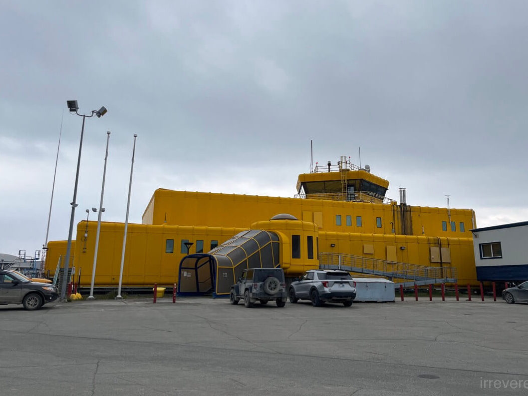
The new Rankin Inlet airport terminal was originally set to open in spring 2025, but its debut has been delayed. The postponed opening allowed us to experience the old terminal before it disappeared into history.


The new terminal has a sleek, modern design, but what really stands out are the tall pipes installed outside. I later learned these are thermosiphon heat exchangers, engineered to protect the permafrost beneath the building from thawing. They function somewhat like a refrigerator, though in a completely passive way: the underground section of each pipe draws heat from the soil, causing the special gas inside to rise to the above-ground portion. Then the gas cools and condenses, releasing heat to the air before flowing back down as liquid to repeat the cycle. This continuous process helps stabilize the ground and preserve the permafrost foundation.

It took approximately another two hours to fly from Rankin Inlet to Iqaluit, the capital of Nunavut. We landed at 6 pm local time (Eastern Time). This flight would then continue south to Ottawa from Iqaluit, which is the same final leg we took seven days later when we ended our Arctic journey.
When we originally booked tickets, the last leg was supposed to be an Iqaluit-Kuujjuaq-Montreal flight, as we wanted to visit one more Inuit village in Quebec along the way. However, Canadian North stopped serving the Kuujjuaq-Montreal flight starting from August 5, 2025, so our route was changed to that direct Iqaluit-Ottawa flight (the final leg of the 5T 118 “Arctic Capital Express”), meaning we didn’t get to see Kuujjuaq.


A side note: each leg of the “Arctic Capital Express” comes with surprisingly decent meals in economy class, even though these are all domestic flights. This is quite rare in North America. I wonder how long this little perk will last.


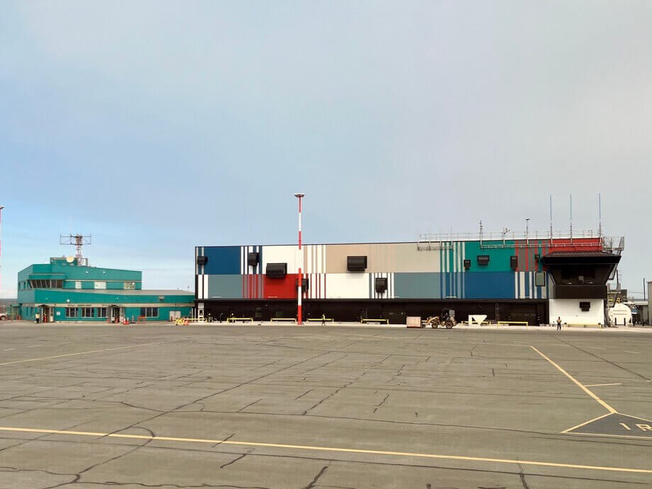
Iqaluit, “a place with many fish”
Iqaluit (Inuktitut: ᐃᖃᓗᐃᑦ), meaning “place with many fish” in Inuktitut, is the capital of Nunavut. With a population of just over 7,000, a few intersections in the town center can actually get congested around noon because the streets are narrow and buildings are concentrated.


All the spaceship architectures are in the city center. It’s a fun city walk.


We initially wanted to try authentic Inuit country food in restaurants, but we couldn’t find any. Fortunately we found some mattak – whale skin and blubber – at the back of a small supermarket. The one we got was quite special because it was a fin from beluga. The store owner told us it would be more chewy than normal ones. I’d never tasted anything like it. The closest comparison I could think of was something like almond-flavored mushroom stems.


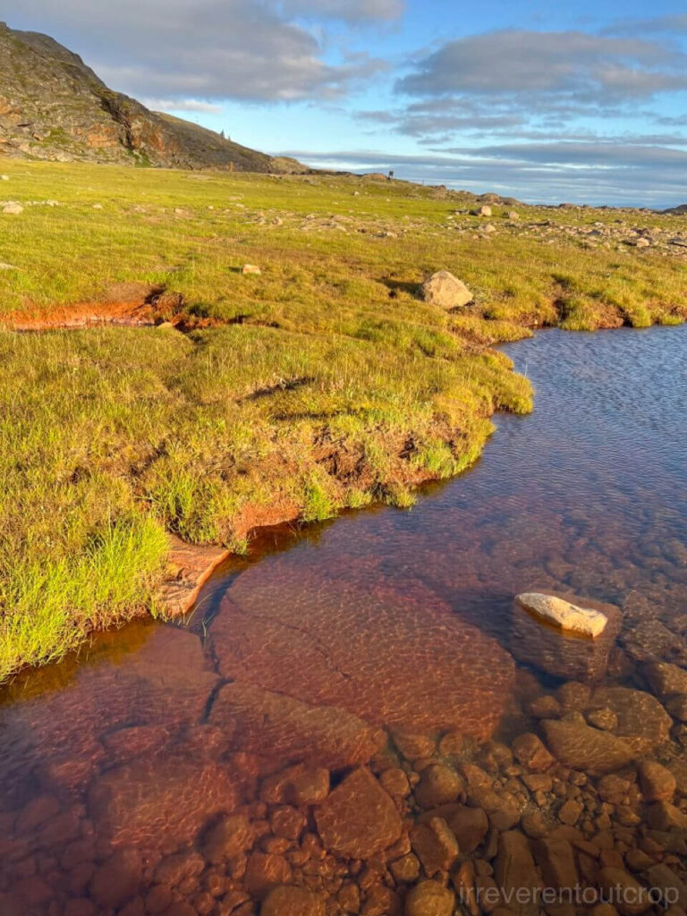
On the western outskirts of town is a park called Sylvia Grinnell Territorial Park, a great place to see the permafrost tundra. Its south entrance is just a short walk from the brewery. Before reaching the park proper, we first crossed a stretch of permafrost and then climbed a small hill to get a view of the Sylvia Grinnell River.


We could easily descend directly from the hill to the riverbank. The riverbed is wide, indicating a substantial flow during spring thaw.


Entering the park from the north entrance offers a different perspective. When we went to the park for the second time, we took a taxi to the northern end of the airport runway, entered the park, and then walked along the trail southwards following the flow of the Sylvia Grinnell River.


Big slabs of Archean gneiss outcrop look slippery. Many of them are covered with dark color lichens.


Another interesting place to visit in town is the Legislative Assembly of Nunavut. While the conference chamber is closed to the public, the hallway on the ground floor is open. The most unique thing in there is definitely that ceremonial mace. It was firstly unveiled in 1999, with a handle made from a narwhal tusk, and the top of a blue lapis lazuli stone sourced from Kimmirut, south of Iqaluit. All other materials also come from various parts of Nunavut.


The Unikkaarvik Visitor Centre is quite interesting as well. The staff are very welcoming, and there are plenty of exhibits. You can even try playing an Inuit drum (qilaut) there.


The weather was quite nice on the day before we left Iqaluit for Pond Inlet, so we decided to hike the entire Apex Trail from Iqaluit to Apex. The cliff trail runs along the coastline with beautiful scenery, ending at the small town of Apex, which was historically a whaling village.


That wraps up the Iqaluit portion of the journey for now. Stories from Pond Inlet and Pangnirtung will follow soon!