My last post covered first impressions of Nunavut’s capital Iqaluit, and this one will continue our journey further up north to the Inuit village of Pond Inlet in Northern Baffin, as well as the adjacent Sirmilik National Park.
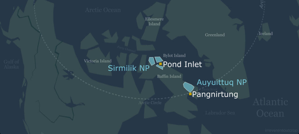
Pond Inlet: “the place of Mittima’s grave”
Pond Inlet is a traditional Inuit village on the northern coast of Baffin Island, right across from Bylot Island. The total population is about 1,600, and 92% of them are Inuit. Deep within the Arctic Circle at an astonishing latitude of 72.7° N, it ranks among the northernmost permanent human settlements in the world. When we visited in August – more than a month after the summer solstice – it was still the season of the midnight sun. The village’s original Inuktitut name is Mittimatalik (ᒥᑦᑎᒪᑕᓕᒃ), meaning “the place of Mittima’s grave”.
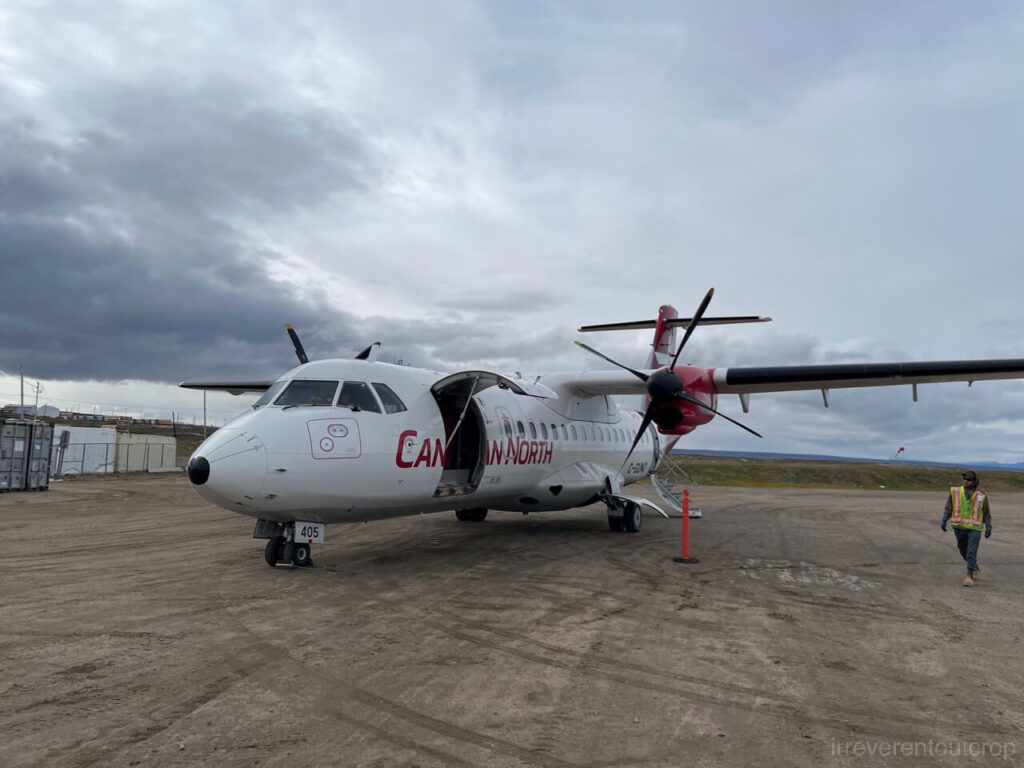
Our 2.5hr flight from Iqaluit to Pond Inlet crossed the entire length of Baffin island. It was over 1,000 km (660mi) long, roughly the same distance as from San Francisco to Seattle. Canadian North used a twin-engine turboprop ATR-42 aircraft for this flight. We picked window seats, hoping to see more of Baffin along the way, but unfortunately it was mostly overcast and we could only saw the landscape during takeoff and landing.

The dining hall at the Inns North is the only restaurant in Pond Inlet. It serves three scheduled meals a day at 7am, 12pm, and 6pm. Rreservations are required. The chefs are from the Philippines and I think they did a decent job considering the limited ingredients available in such a remote area. The dining hall is always packed, as many of the guests are seasonal construction workers from the south who stay in the rooms upstairs.


The day we arrived in Pond Inlet happened to coincide with the arrival of the year’s last supply ship, so the two local grocery stores were surprisingly well stocked, with fresh fruits and vegetables too. The stores were bustling with people everyday – adults and children alike happily carrying cases of Coca-Cola to the checkout.
Passionate Inuit kids
Pond Inlet is a small village that you can easily explore on foot. Aside from its two grocery stores, it has two schools, a hospital, a small museum, and a national park visitor center. Although the sun never really set during our stay, temperatures hovered only around 2-5°C (35-40°F), with steady winds. We were bundled up in several layers of winter clothing, while the local children ran around in thin hoodies. Some even run barefoot in shorts and T-shirts. That’s some hardy genes at work!
The kids in Pond Inlet are bursting with energy and warmth. Whenever we walked through the village, they would greet us enthusiastically and strike up conversations. Their clear eyes and carefree laughter felt like something rare in today’s world. They spoke Inuktitut among themselves, but their English was fluent that chatting with us was effortless. Many liked to ride bicycles, while others simply dashed around the streets for fun.
One really funny thing that definitely worth calling out: a boy greeted me then said I looked like “Yamin” before running off. I didn’t understand what he meant at first – maybe “Yamin” was someone from his family? A little later, another kid playing basketball in his yard also called me “Yamin” then tossed me the ball and shouted for me to “dunk like Yamin”! That’s when it hit me – they meant the basketball player Yao Ming.
From then on, almost every child between 6 and 13 years old who saw me would say I looked like Yao Ming or call me “Yao Ming Junior”. When I asked which part do I actually look like him the most, they all gave the same answer: the jawline. A very odd but impressively consistent observation.
Even though Yao Ming retired years ago, his fame clearly lives on up here. In Iqaluit and later in Pangnirtung, we never received such a warm, VIP-style welcome – something truly unique to Pond Inlet.

However, according to others, while the younger kids are full of energy and enthusiasm, rates of depression and suicide are actually quite high once they reach high school age. There have even been sad instances of group suicides. At first I instinctively thought the long, dark polar nights might trigger depression, but they said it’s mostly in spring and autumn. Locals actually enjoy the winter polar night – partly for the northern lights, partly because the absence of the sun means little wind and a deep, peaceful quiet, and partly because their activity range can extend all the way to the edges of the sea ice. In contrast, the sunrises and sunsets of spring and autumn, along with more unstable weather, tend to trigger mental instability more often.
The deeper cause is likely to be related to the social reality: the disconnect between modern life and traditional nomadic ways, sky-high costs for any travel route to the outside world, and the scarcity of job opportunities. On top of that, the internet gives people access to information about the wider world, yet in daily life they can hardly experience it firsthand.
As outsiders, we can only scratch the surface of their living experiences. I genuinely wish they can overcome whatever challenges they will be facing and thrive in the future.
“The Jewel of the North” and its majestic natural scenery
The village sits right on the coast, with sea cliffs and glaciers of Bylot Island visible across the inlet, offering spectacular views at every turn in the village. Even our small lodge room came with an unbeatable view of the Arctic waters. In the vast expanse of Canada’s polar regions, only this place is called “The Jewel of the North,” and it’s easy to see why.
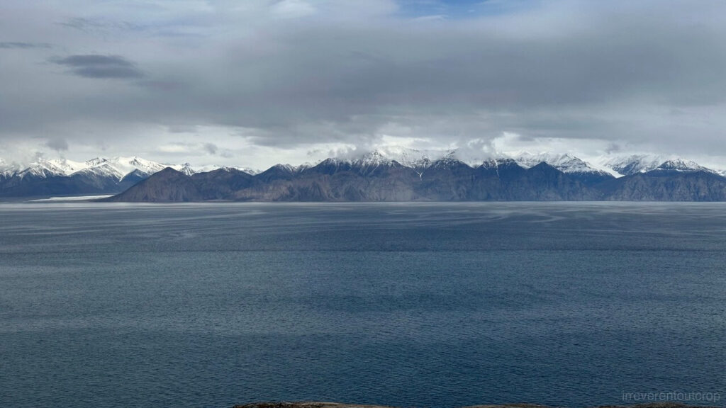
Almost the entire Bylot Island, except for a small section in the southwest, consists of Precambrian crystalline country rock, with varying degrees of metamorphism from gneiss to granite. The landscape is heavily sculpted by glaciers, rugged and deeply incised with countless valleys. When we look at the island from the village, the dark gray mountains, white snowcaps, and pale blue glaciers create a striking contrast.
The inlet between Bylot Island and Baffin Island may look calm on the surface, but locals told us that strong undercurrents run beneath, making it a passage only experienced sailors would dare to cross. When the sea ice melts in spring, the water conditions become even more complex.
Looking toward the glaciers on Bylot Island from the village, the one slightly to the west is called the Sermilik Glacier. Although spelled “Sermilik”, it is actually the same word as the national park’s name “Sirmilik” in Inuktitut, meaning “place of glaciers”. Several glaciers and fjords in Greenland also derive their names from this word.

There’s a narrower glacier called Kaparoqtalik Glacier just to the east.

The southwestern corner of the island, where the sedimentary rocks are located, is flat and low-lying. It serves as an important habitat for snow geese and Arctic foxes. The snow goose population here is said to reach tens of thousands.
We saw helicopters carrying boxes flying from the village to this area in the mornings. Later we learned that they were delivering supplies to research teams camped on the island. Over a dozen groups were there studying various topics. On our flight back to Iqaluit, we even met three researchers who had just completed a three-month field study on Arctic foxes on Bylot Island and were heading back to Quebec. I couldn’t quite remember whether they were from Université Laval or Université du Québec à Rimouski.
The country rock on the Baffin Island side where the village itself is located is also part of the Canadian Shield. Gneiss from the Archean Eon is found everywhere: hard and beautifully patterned.


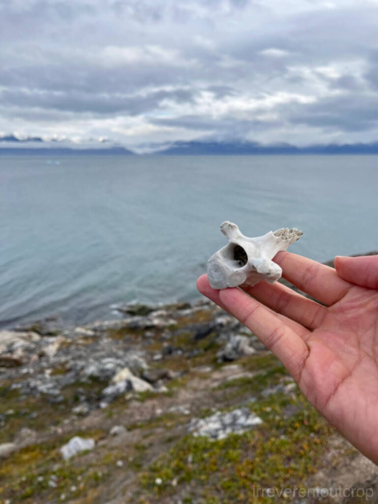
Besides the ancient gneiss, the coastal areas often reveal smaller but fascinating discoveries, including Arctic-specific plants and wildlife. These details give the region its distinctive Arctic character beyond the dramatic geology.

The sea cliffs and glaciers of Bylot Island are already spectacular when viewed from the village. But what would it be like to get even closer by boat?
Visiting Sirmilik National Park and Bylot Island
We had to register at the park’s visitor center and attend a brief safety and guidelines talk before setting off by boat to Sirmilik National Park. But Canada happened to offer free admission to all national parks from June 20 to September 2, 2025, so our entry was free.

This national park is truly remote – it’s already August and only 14 visitors had come before us this year. The park staff Darrell was exceptionally welcoming and helpful. We contacted him in advance to schedule the talk and the registration.
The park’s protected area extends beyond the land to include a large surrounding marine zone. Its marine ecosystem is quite unique here: as the ice in the inlets and fjords melts every June, large numbers of marine mammals such as belugas, narwhals, bowhead whales, walruses, and seals from the outer Baffin Bay move in to feed and give birth. Then before the inlets refreezes in September, they’d rush back out. There are about 100,000 narwhals globally and 75-85% of them visit this particular area each year, making it the densest narwhal population in the world.


Right: A map of the national park and its surrounding marine protected area. Green indicates land, while dark blue represents the ocean.
The sky hung overcast the morning we were to depart, yet the sea lay calm beneath it. Our Inuit guide is 74 years old and still in such excellent shape that he had just returned from a multi-day hunting trip. One of his sons was also on board to help out. The boat we rode on wasn’t a special tour vessel but their actual fishing boat. It was quite fun to sit among their various fishing gear, harpoons, and floats: it felt more like a real hunting trip than a tour.
Some sections of the inlet reaches depths of nearly 1,000m (3,300 ft)- quite astonishing for an inlet looks this narrow.


We reached the edge of Bylot Island after about an hour. We were able to get a close-up view of the glaciers here.


Our guide explained to us that Sermilik Glacier used to extend all the way into the sea, but unfortunately it has been steadily retreating in recent years and become a land-terminating glacier and revealing a coastline littered with moraine debris.

The swell began to pick up after we got to Bylot Island. We not not able to get ashore and had to follow the coastline eastward by boat.

The peaks east of Sermilik Glacier rise to around 700m (2,300ft), with large talus aprons extending down from the middle.


The talus deposits thin out as we move east. More crystalline country rock appears as the sea cliffs grow steeper.

Just before reaching the second glacier, Kaparoqtalik, the towering sea cliffs drop almost straight into the sea with little talus at their base. Several dyke intrusions are also visible along the cliff faces.


After passing Kaparoqtalik Glacier, we continued eastward toward the third glacier, Narsarsuk.


The ice tongues of all three glaciers are set back from the coastline, so it’s slightly difficult to fully grasp their scale when we were close from the boat. The sea cliffs along this stretch however left a stronger impression: sheer cliffs 600-700 meters high plunging right into the sea, with abundant dykes and joints visible in the rock faces.
After a brief rest at Narsarsuk Glacier, we turned back toward Baffin Island. As we slowly gained distance from Bylot Island, the higher, snow-capped inland horns gradually came back into view.

When were approached the Baffin Island side, the first thing we saw was the front face of Mount Herodier, east of the village of Pont Inlet. We had only seen its side from the village before, which looked like a sharp triangle. This frontal view, however, is completely different.
Mount Herodier is separated from the rest of Baffin Island by a glacier-cut U-shaped valley.


A blue iceberg floats offshore from Mount Herodier. We sailed right alongside it and could see many seagulls resting on its surface.

Finally we safely returned to the village!

We saw seals and walruses from afar on the boat trip but missed the narwhals. Yet that small letdown was made up for in a surprising way later that evening after dinner…
Whaling
[Note: The photos in this section are meant to document traditional Inuit practices. There is no intent of sensationalizing or provoking. Some whaling scenes may be disturbing to certain readers though – discretion is advised.]
Our dinner ended around 7:30pm, yet the sky remained overcast with no sign of getting dark any time soon. On our walk back to the lodge, we ran into one of the kids that had enthusiastically nicknamed me “Yao Ming Junior” playing basketball. After greeting him, he said, “Oh, by the way, a lot of people from the village have gone out whaling. You can go take a look if you want.” I asked, “That sounds really interesting, but why aren’t you going?” He replied casually, “Nah I saw it all the time…” and then went back to playing basketball.
Curiosity and excitement pulled us toward the port. As soon as we reached the cliff edge, we realized the scale of the whaling operation was far larger than we had imagined…

About twenty small boats were maneuvering in various formations on the water, with occasional gunshots echoing across the inlet. Several men with hunting rifles spread along the cliff edge, keeping a close watch on the water. It feels like most of the families of the village came out to see this, as if enjoying a prime-time drama after dinner.
A local gramma told us that the hunters saw some narwhals and then asked many others to join the hunt. Typically several boats would work together to encircle the whales, while people on shore keep watch to prevent any whales from escaping the boat siege.
Around 8pm, we saw someone on one of the boats dragged a whale out of the water and hooked it at the bow. Soon most of the boats began heading back, and we followed a group of bouncing, excited children toward the dock.


A crowd had already gathered at the dock when we arrived. Several young men who led the hunt were busy cutting them up with sharp knives. They had caught two narwhals: a calf and a female, so neither had tusks – only adult males have those iconic spiral tusks. The locals were impressively skilled – each cut was fast and smooth. Strips of “mattak” (whale skin) were neatly removed and put into large containers. One of the young men, probably feeling hungry or tempted, cut himself a large piece during the break, rinsed it in the seawater, and bit right in – definitely some strong teeth there!
Someone posted about this hunt in the village’s Facebook group, so the word had spread quickly and villagers of all ages showed up with bags and boxes. Each of them grabbed a few pieces of mattak, caught up with their friends for a bit, then left. Many mothers came wearing amauti with babies strapped on their backs. The amauti is a traditional thick Inuit coat, distinguished by a large pouch on the back where a child can stay close to the mother’s body for warmth.

What surprised me was that they didn’t actually keep the whale meat. They only kept the skin and the blubber beneath it. The bones and internal organs were left untouched as well. By 9pm, once the mattak had been distributed, they hooked the remaining carcass onto a boat and towed it out to drop them back in the middle of the inlet. A large flock of seagulls approached immediately afterwards.
The dock smelled nothing fishy even though blood was everywhere, because narwhals are mammals.
The hunt started around 7pm and everything ended at 9pm. It only took them around 2hrs to do the whole process of noticing the whales, forming a siege, catching the whales, returning to the dock, butchering, distributing the skin, and cleaning up. Everything was completed in one seamless, highly efficient operation.
The Inuit way of living
The Canadian government did not force the Inuit to abandon their nomadic lifestyle until after World War II. The goal was simply to use Inuit permanent settlement to claim sovereignty over the Arctic islands. If we calculate the years, we’d notice that many of the village elders – including our boat tour guide- were probably born in tents out in the wild. They personally experienced the transition from a fully nomadic life to forced settlement, followed by the era of self-governance, and yet they continue to live with passion and dedication to their community. Such a remarkable resilience.
Many Inuit were treated brutally when the Canadian government employed harsh measures to compel Inuit settlement in the 1950s and 60s. For example:
- Families from Nunavik (Northern Quebec) were taken to the north of Parry Channel to extremely harsh, uninhabited areas like Dundas Harbour (now abandoned), Resolute, and Grise Fiord.
- Royal Canadian Mounted Police killed sled dogs, which were essential for survival.
- etc.
The Inuit survived despite these hardships. Many aspects of their traditional nomadic Arctic lifestyle have been preserved even though most are now settled. Besides whaling, they frequently go “camping”- not in the tourist sense but for hunting trips lasting from a few days to even a month or longer. They hunt caribou in summer, and camp on the ice in winter to fish or hunt seals. Meat is often eaten raw to supply necessary nutrients because their traditional diet lacks fruits and vegetables.
The only locally-grown fruit is blueberry. Blueberry picking is such a major activity in summer that posts about blueberry picking in their Facebook groups are just as popular as hunting updates.

The traditional Inuit lifestyle is largely self-sufficient. However, there are still expenses that require cash in modern times: things like gasoline, vehicle and boat repairs, hunting firearms, and imported drinks or snacks. Housing, utilities, and heating for settled communities are mostly provided by the government, with families reportedly paying only around $40 per month.


Right: Cute couch covers in the museum. The blue one features an inuksuk pattern. Inuksuks are stone markers traditionally built by Inuit in the wilderness to mark direction or locations. The orange cover shows the “women’s knife,” or ulu, a traditional Inuit tool with a crescent-shaped blade and a handle above the center of the blade. It is mainly used by women for cutting animal skins and fish.
One interesting cultural detail: doors of Inuit homes are never locked here. People don’t knock when visiting relatives or friends. They simply just walk right in. It’s said that only the police knock when looking for someone, so if you were to knock while visiting, it might actually startle the hosts.
Permafrost
We left the village to explore Salmon Creek to the west on our last day in Pond Inlet. It’s near Tamaarvik Territorial Park and is a popular spot for local fishing and camping. We got there simply by following the beach westward from the village. The path is quite straightforward.


The permafrost along this stretch of coast seems to lie directly atop the sand. A clear boundary between the permafrost and the sand can be seen in exposed sections,.

It was about a 45-minute scenery walk to get to Salmon Creek. The creek’s current was strong that we didn’t cross to the other side. Several Thule archeology sites sit right across the creek. The Thule people, ancestors of today’s Inuit, were active from around the 10th to 13th centuries across the vast Arctic region from Alaska to Greenland.

This land is quiet and desolate. Clear pure water runs through it and grasses and mosses grow strong in its stillness. A serene calm spreads across the surroundings and the air feels sharply refreshing. I wonder how winter would change it and see a world transformed under frost and snow.

The end
Surpassing Anaktuvuk Pass, Pond Inlet became the northernmost place I’ve ever been. With its spectacular glacial landscapes and unique Inuit culture, it truly feels like a hidden paradise!


We then flew back to Iqaluit for a brief stopover before continuing on to Pangnirtung, a fjord village in southeastern Baffin Island.